Apart from informing the public and authorities, much science can be done with DYFI inquiries! Given it is not possible to install seismometers everywhere in the country, the human’s perception is a particularly good measuring device for estimating ground motion. Apart from AcceleROB (installing low costs accelerometers in Belgium) DYFI intensity assessment is currently the only tool to provide ground motion velocity from poorly-instrumented regions to engineers. That is why we need your input! Macroseismology allows studying the intensity decay with increasing distance from the earthquake’s epicentre, and understanding how the regional geology or local site effects influence the ground motion experienced at the Earth’s surface.
22 July 2002 ML 4.9 Eschweiler-Alsdorf earthquake (DE)
The Alsdorf event, an earthquake that occurred along one of the normal faults of the Lower Rhine Graben in Germany, gave the opportunity to activate for the first time our online macroseismic survey. To this day, it is still by far the most successful event as 6145 forms were submitted to Seismology.be. At that time only a Belgian intensity analysis was performed with most of the responses coming from Flanders. The highest intensity in Belgium was Intensity IV (EMS-98 scale) until a distance of 45 km from the earthquake’s epicentre. In Belgium intensity decreased westwards. The event was felt at large epicentral distances by people living at the Belgian coast or in the Ardennes (Camelbeeck et al., 2003). Intensities declined more rapidly to the N and NW than to the W and SW.
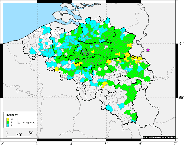
Figure 3: First Belgian web-based macroseismic DYFI map of the 2002 Eschweiler-Alsdorf earthquake. The pink start indicates the epicenter.
2008-2010 Walloon-Brabant Seismic Swarm (BE)
Between 2008 and 2010, 237 earthquakes with magnitudes between ML -0.7 and ML 3.2 occurred south of the small town of Court-Saint-Etienne (Walloon Brabant Province, Belgium) (Van Noten et al., 2015a). During this 2-year period, 60 of the 237 measured events were felt, which resulted in an enormously-rich database of 11040 responses. Remarkably, also very small events and shallow events were perceived by the local population: e.g. 5 responses for the 21 October 2008 ML 0.4 event. The fact that these responses were submitted even before any information was placed on the website makes us confident that this event was really perceived.
The 13 July 2008 ML 3.2 earthquake (1495 responses) was the largest and the most widely perceived of the events. The felt observation with largest epicentral distance was reported at Bressoux (Liège), 71 km E from the epicentre, whereas the farthest report north was only at 42 km (Zemst). The ML 3.2 caused only Intensity III in the epicentral region, which is in agreement with its medium depth (7.7 km). Despite its lower magnitude, the 3 March 2009 ML 2.8 event (1581 responses) and some other events caused Intensity IV in the epicentral area due to its shallower depth (6.3 km) (Van Noten et al., 2015b; Consentino, 2016).
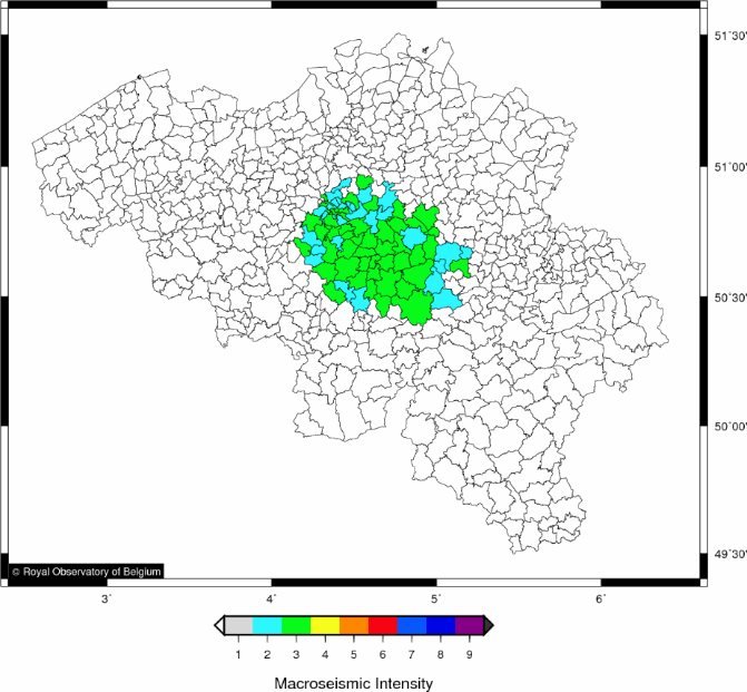
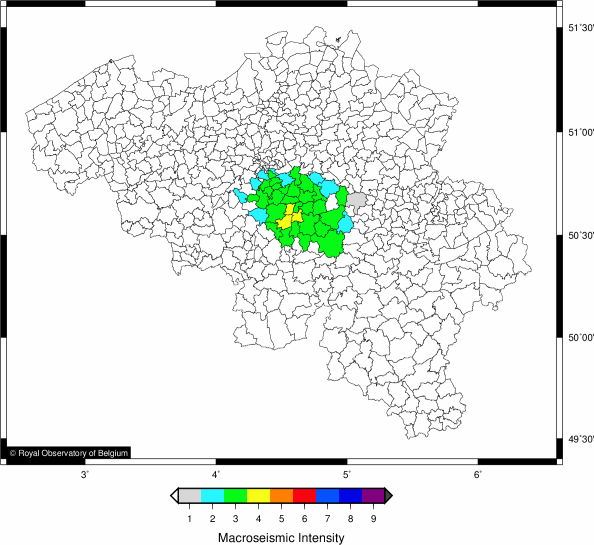
Figure 4: Macroseismic DYFI maps of the 13 July 2008 ML 3.2 (left) and the 3 March 2009 ML 2.8 (right) events. Note the higher intensity but smaller affected area for the ML 2.8 earthquake.
Because of the rather shallow source of the earthquakes and the relatively close distance of the respondents to the earthquake hypocentres, many low-magnitude events have been heard rather than felt. Typical reactions of people reporting these acoustic effects were low frequency sounds, such a ‘boom’ or a deep ‘rumbling’ sound comparable to a ‘thunder’ or a ‘passing truck’. However, also high frequency acoustics such as a loud ‘crack’ or a ‘bang’ were reported. Based on these comments, our online inquiry was extended in 2009 with a sound question in which the reported sound is questioned: the sound scale is currently settled from 0 to 4, with 0 being “no sound”, 1 “light and brief”, 2 “light and prolonged”, 3 “strong and brief” and 4 “strong and prolonged” to hint on the frequency content of the sound.
8 September 2011 ML 4.3 Goch earthquake (DE)
On 8 September 2011 19:02:50 an ML 4.3 earthquake occurred at Goch (DE) at a depth of 10 km on one of the bounding faults of the Venlo Graben. Minor damage was reported in the epicentral area in Germany and The Netherlands. 3113 responses were submitted for this first event after ROB and BNS merged their inquiries.
In contrast to the NE part of Belgium, where the event was barely felt, many macroseismic reports were submitted from central Belgium at larger epicentral distances. This shows that the peculiar shape of the intensity distribution cannot be explained by a traditional geometrical amplitude attenuation alone, relating energy decay to the increasing epicentral distance. In central Belgium, the Brabant Massif is present at the surface in incised river valleys and it gradually deepens towards the north where it is covered by soft sediments. The macroseismic distribution of the 2011 Goch earthquake exemplifies that the area over which this event was felt is related to the thickness of the sediment cover above the Brabant Massif and that sediments have a significant influence on earthquake strong ground motions. To the north of Brabant (Limburg & Antwerp provinces) vibrations are attenuated (damped) due to the thick Cenozoic sediment cover. In central Belgium, the felt shaking is related to an E-W elongated zone with sediment thicknesses that amplify seismic waves in the frequency range to which humans and buildings are susceptible.
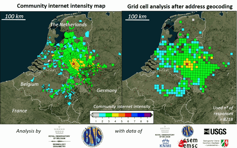
Figure 5: Macroseismic DYFI maps of the 8 September 2011 ML 4.3 earthquake near Goch. The community internet intensity macroseismic map (left) and the geocoded, grid cell intensity map (right) results after merging macroseismic databases from 6 different institutes. This example shows the benefit of transfrontier collaboration in macroseismology. Source: Van Noten et al. (2017).
22 May 2015 ML 4.2 Ramsgate earthquake (UK)
On Friday 22 May 2015 at 03:52:17 (local time) an earthquake with magnitude ML 4.2 occurred close to Ramsgate (UK) at a depth of 15 km. By evaluating other macroseismic inquiries it could be deduced that the event was felt in the UK, in France and in Belgium. The ROB received 1986 responses from people that felt it in Belgium with the farthest report at Liège, more than 400 km away from the epicentre. Similar to the 2011 Goch and 1938 Zulzeke-Nukerke macroseismic distributions, the shallow depth of the Brabant Massif in central Belgium is the main reason why this event was so broadly perceived.
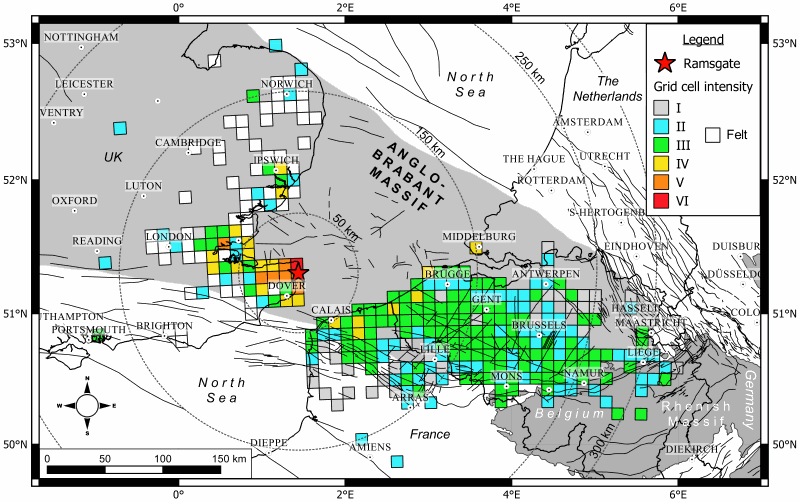
Figure 6: Macroseismic distribution of the 22 May 2015 ML 4.1 earthquake near Ramsgate (UK) showing how the event was perceived in Belgium. The epicentre is indicated by a red star.
Belgian press articles on the Ramsgate earthquake:
- “Ook België beefde even vannacht”, De Standaard Avond. 22/05/2015.
- “Aardbeving Kent voelbaar tot in België”, Het Laatste Nieuws. 23/05/2015.
- “1.000 mensen voelen aardbeving in België”, Het Nieuwsblad. 23/05/2015.
- “Aardbevingen in België: zelden gevaarlijk maar vaker dan je denkt”, De Morgen 23/05/2015.
References
- Camelbeeck, T., Van Camp, M., Martin, H., Van De Putte, W., Béatse, H., Bukasa, B., Castelein, S., Collin, F., Hendrickx, M., El Bouch, A., Petermans, T., Snissaert, M., Vanneste, K., Verbeiren, R., 2003. De aardbeving van 22 juli 2002 in de Roerdalslenk. Heelal 48, 172-176.
- Consentino, B.C., 2016. Macroseismic intensity assessment of the 2008-2010 Walloon Brabant seismic swarm by a grid cell procedure, Katholieke Universiteit Leuven. B.Sc. Thesis. Promotors: K. Van Noten (ROB), M. Sintubin (KULeuven).
- Van Noten, K., Lecocq, T., Shah, A.K., Camelbeeck, T., 2015a. Seismotectonic significance of the 2008-2010 Walloon Brabant seismic swarm in the Brabant Massif (Belgium). Tectonophysics 656, 20-38. DOI: http://dx.doi.org/10.1016/j.tecto.2015.05.026
- Van Noten, K., Lecocq, T., Camelbeeck, T., 2015b. The seismic activity in the Walloon Brabant and its relationship with the local and regional geological structure. Final report of BELSPO contract MO/33/028. Royal Observatory of Belgium. 79p.
- Van Noten, K., Lecocq, T., Sira, C., Hinzen, K.-G., and Camelbeeck, T. 2017. Path and site effects deduced from merged transfrontier internet macroseismic data of two recent M4 earthquakes in northwest Europe using a grid cell approach, Solid Earth, 8, 453-477, https://doi.org/10.5194/se-8-453-2017.