Background
FAULTCOLLAB is a research project in earthquake geology and tectonic geomorphology of active faults in intraplate context between the Seismology-Gravimetry Department of the Royal Observatory of Belgium (ROB) and the Unit of Physical Geography and Quaternary of ULiège (UGPQ) in the frame of the FED-tWIN programme of the Belgian Science Policy Office (BELSPO).This project focuses on two lines of expertise in which the two research groups have built a strong tradition:
- Earthquake geology (or paleoseismology), a research topic developed over the past two decades at ROB, involving the identification of active faults and folds, the analysis of coseismic deformation in sediments of the shallow subsurface, to determine the size and timing of past large earthquakes.
- Tectonic geomorphology, a strong research topic at UGPQ, investigates the expression of active tectonic deformation in the landscape and topography, in order to quantify the amount and rate of deformation. Such analysis will be complemented by various other disciplines, like physics of the earthquake source, remote sensing, Quaternary geology, geophysical surveying (e.g., seismic reflection profiling, electric resistivity tomography, ground-penetrating radar), sediment analysis and geochronology.
General objectives, study area and relevance for society
The FAULTCOLLAB project has the objective in the context of “stable" continental regions (also referred as intraplate) like Belgium, to advance our understanding of:- active faults, their behaviour (seismic and aseismic components) and rate of deformation;
- the recording of past large earthquakes in the landscape and in the sedimentary record;
- the history (size, timing) of large earthquakes on individual faults or fault segments.
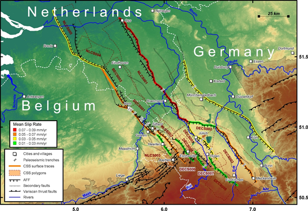
FAULTCOLLAB will mainly focus on two study areas where both ROB and UGPQ have a long track record of studying active faults: the Roer Valley Rift System (RVRS) in the border area of Belgium, the Netherlands and Germany, and the Hockai Fault Zone (HFZ) in the Belgian Ardenne. The RVRS is an active system of normal faults with a total length of more than 550 km. It is one of the most seismically active areas in Europe north of the Alps, and one of the only intraplate areas where earthquakes can be linked to known faults (Figure 1). As such, it constitutes an ideal, easily accessible natural laboratory where active faults and their associated surface deformation can be investigated. The MW=5.3 Roermond earthquake in 1992, the largest instrumentally recorded earthquake in the RVRS to this day, prompted interest in the seismicity and active tectonics of this structure, leading to the first successful paleoseismic studies in intraplate Europe (Camelbeeck & Meghraoui, 1996), which demonstrated that large earthquakes ruptured the ground surface in the recent past in the RVRS (EC-projects PALEOSIS and SAFE). More recently (EC-project SHARE), a first parameterized fault-source model of the RVRS that can be used in seismic hazard assessments (SHA) was developed based on a review of data available in the literature (Vanneste et al., 2013).
A better understanding of active faults in our regions is relevant for the seismic safety of our society. More reliable fault models will allow improving seismic hazard assessments and simulations of earthquake ground motion, which is important for critical infrastructure like Seveso industries and nuclear facilities, but also for revisions of the building code Eurocode 8.
Specific objectives and research methods
Although our knowledge of the faults in the RVRS has increased since the 1992 Roermond earthquake, the level of knowledge is not homogeneous and far from complete. One of the most important parameters to assess the activity of a fault is the slip rate. This quantity can be determined from vertical offsets of geomorphic and stratigraphic markers, but the number of available offset markers is highly variable. For most faults, there are only a few observations, which often do not cover the whole relevant time span. Moreover, a number of important fluvial terraces remain poorly dated. Most information is also scattered and an open database that can be updated by the paleoseismic community is lacking.To fill in these gaps, the specific objectives within the first two years of the project are:
- To perform a detailed, field- and LiDAR-based analysis of the along-strike geometry and scarp morphology of RVRS faults at the surface.
- To carry out a systematic inventory of all available data on offset Quaternary geomorphic and stratigraphic markers in the RVRS in a fault-displacement database containing formal uncertainties;
- To extend this fault-displacement database based on new or derived data, such as (1) relevant information extracted from existing subsurface information; (2) analysis of near-surface geophysical and borehole data, both existing and newly acquired; (3) analysis of fault scarps using high-resolution topographic profiles or swaths extracted from LiDAR data; and (4) re-analysis of published paleoseismic dating results to obtain refined paleo-earthquake ages and associated offsets;
- To explore alternative techniques of investigation, e.g., conducting shear-wave seismic reflection profiles across faults to bridge the gap between near-surface geophysics and existing traditional seismic-reflection data; recording ambient noise to image the faults at greater depth; analysing remote sensing imagery etc.
Nevertheless most other faults of the Roer Valley Rift System still suffer from lack of investigation, which limits the estimation of the ages or recurrence time of past earthquake as well as their precise location and lateral extent. As a result, the level of knowledge on the faults in the RVRS is not homogeneous, which encumbers their inclusion in seismic hazard assessment.
A first step will be to identify promising sites for recovering a paleo-earthquake record, where detailed site investigations will be performed (geophysics, geomorphology), and then possibly trenching. Such data will not only help to retrieve the earthquake history of this fault system but also to obtain information about the variations, in space and time, of the balance between seismic fault slip and aseismic strain release. In parallel, collaborations will be established with international teams working in the same area. These efforts should lead to the investigation of new paleoseismic trenches in the following years, in order to increase the spatio-temporal record of paleoearthquakes in the RVRS and the surrounding areas (e.g., the North Artois Shear Zone in northern France and the English Channel; the Upper Rhine Graben along the French-German border).
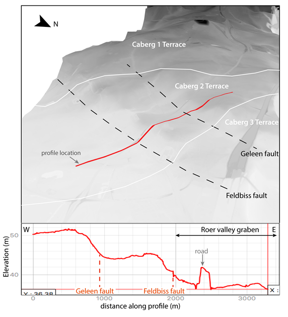
High-resolution digital elevation model of the Roer Valley Rift System
In recent years, new LiDAR elevation data have become available with unprecedented resolution and geographical extension allowing more detailed geomorphic analysis. In the area of the RVRS, the four surrounding countries have acquired during the last 6 years airborne LIDAR data, and distributed as open products the DEMs generated from this LIDAR acquisition. For the Netherlands the AHN3 dataset (2014-2019) is available for the whole country at a 0.5m-resolution. The Flanders, Wallonia and North Rhine- Westphalia provide a DEM with a resolution of 1.0m through their respective geoportals. These different national datasets will be used to construct a cross-border DEM.The resulting LIDAR-based DEM will be used to refine the fault trace and scarp geometry (Figure 2), to better understand the fault branching and linkage processes, and to analyse along-strike variation of topographic offset in relation to surface geology. Moreover, the vertical offsets can also be measured, especially in the areas of fluvial terraces, where they will provide constraints on the fault slip rates. In areas like the Roer Valley Rift System, characterized by low rates of deformation, the tectonic signal is often overprinted by other natural or anthropogenic processes, thus only high resolution DEMs like the LIDAR derived ones can allow to retrieve detailed tectonic information. The regional extent of this homogeneous high-resolution dataset will also allow us to build a more complete and uniform database at the scale of the entire fault system.
Such data associated to an improved fault model will help to build a more physically realistic description of seismicity and earthquake sources in probabilistic seismic hazard assessment (SHA), as well as to develop more sophisticated simulation of ground motion in deterministic SHA scenarios.